
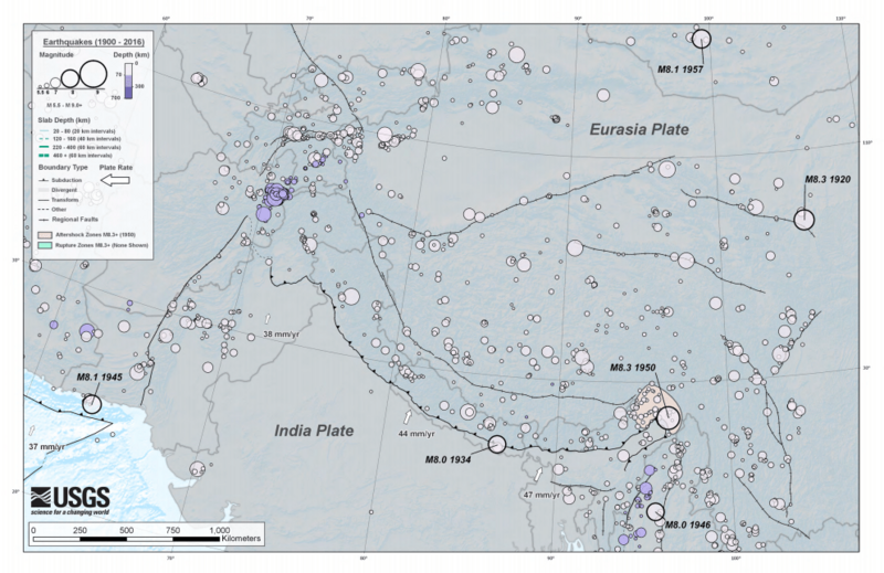
Image: EQs 1900-2016 himalaya tsum

Description: Earthquakes M5.5+ (1900-2016) himalaya Circle sizes indicate Magnitude, and colors indicate their depth.
Title: EQs 1900-2016 himalaya tsum
Credit: https://earthquake.usgs.gov/earthquakes/byregion/ https://earthquake.usgs.gov/earthquakes/eventpage/nc72906781#map?Historical%20Seismicity=true&Population%20Density=true&ShakeMap%20MMI%20Contours=false https://earthquake.usgs.gov/earthquakes/tectonic/images/aleutian_tsum.pdf https://earthquake.usgs.gov/earthquakes/tectonic/images/caribbean_tsum.pdf https://earthquake.usgs.gov/earthquakes/tectonic/images/eastafrica_tsum.pdf https://earthquake.usgs.gov/earthquakes/tectonic/images/emaustralia_tsum.pdf https://earthquake.usgs.gov/earthquakes/tectonic/images/himalaya_tsum.pdf https://earthquake.usgs.gov/earthquakes/tectonic/images/japan_tsum.pdf https://earthquake.usgs.gov/earthquakes/tectonic/images/kuril_tsum.pdf https://earthquake.usgs.gov/earthquakes/tectonic/images/mediterranean_tsum.pdf https://earthquake.usgs.gov/earthquakes/tectonic/images/mexico_tsum.pdf https://earthquake.usgs.gov/earthquakes/tectonic/images/middleeast_tsum.pdf https://earthquake.usgs.gov/earthquakes/tectonic/images/newguinea_tsum.pdf https://earthquake.usgs.gov/earthquakes/tectonic/images/philippinesea_tsum.pdf https://earthquake.usgs.gov/earthquakes/tectonic/images/qcf_tsum.pdf https://earthquake.usgs.gov/earthquakes/tectonic/images/southamerica_tsum.pdf https://earthquake.usgs.gov/earthquakes/tectonic/images/sumatra_tsum.pdf
Author: USGS
Usage Terms: Public domain
License: Public domain
Attribution Required?: No
Image usage
The following page links to this image:
