
Image: EasternBloc
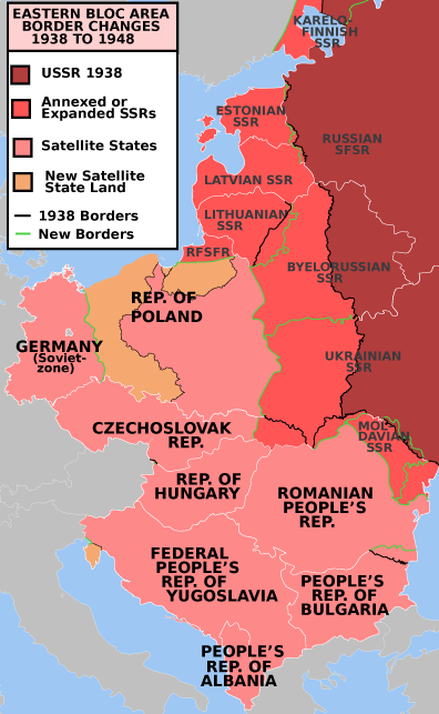
Description: Description: Former Eastern Bloc area border changes between 1938 and 1948. Source: Map borders primarily based on File:EC12-1986 European Community map.svg and File:Blank map of Europe in 1920.svg. Author: Mosedschurte, June 1, 2009 The border and other changes include: The creation of the satellite states (note: this was before the Tito-Stalin split and the Hoxha 1960 split) The annexation of the Baltic states The annexation of the Moldavian SSR The Transnistria exchange between the Ukrainian SSR and the Moldavian SSR The annexation of northern Bukovina, the Hertza region and northern Bessarabia. The annexation of the Izmail Oblast The Territories of Poland annexed by the Soviet Union The transfer of part of East Prussia and the territories east of the Oder-Neisse line from Germany to Poland The annexation of the Kaliningrad Oblast The transfer of Southern Dobruja from Romania to Bulgaria The Bratislava Bridgehead transfer from Hungary to Czechoslovakia The transfer of the Latvian eastern Abrene district to the RSFSR The transfer of Estonian territories north and South of Lake Peipus to the RSFSR The annexation of the Vilnius region from Poland to the Lithuanian SSR The annexation of part of the Karelo-Finnish SSR The annexation of Carpathian Ruthenia The transfer of the Italian Istria peninsula to Yugoslavia.
Title: EasternBloc
Usage Terms: Creative Commons Attribution-Share Alike 3.0
License: CC-BY-SA-3.0
License Link: http://creativecommons.org/licenses/by-sa/3.0/
Attribution Required?: Yes
Image usage
The following page links to this image:
