
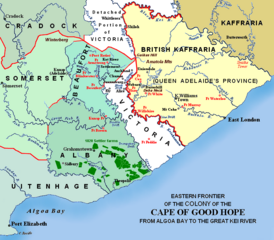
Image: Eastern Frontier, Cape of Good Hope, ca 1835

Description: Eastern frontier(s) of the Cape of Good Hope colony, ca 1820 – 1850 (i.e. period between 5th and 8th Xhosa Wars) 1820 British settler farms in the Albany district, or eastern Zuurveld Settled colonial area (est. 1795), showing Grahamstown (est. 1812), and districts (est. 1820) in shades of pale green Neutral zone (est. 1820), as agreed between Lord Charles Somerset and the Gaika (Ngqika) faction of the amaXhosa. British Kaffraria (est. 1835), incl. East London (est. 1847): Gaika faction of amaXhosa and amaTembu under British protection. Kaffraria, incl. Butterworth Wesleyan mission (est. 1827): amaTembu living inland and amaXhosa nearer the coast. Mountains and necks, incl. Gaika's Hill 32°32′46″S 26°57′07″E / 32.54611°S 26.95194°E / -32.54611; 26.95194 (Gaika's Hill) in the easternmost Winterberg. Military forts, district boundaries and eastern frontier. Notes Frontiers: Following the 5th Xhosa War (ended 1819), the Keiskamma River up to Gaika's Hill, and thence westwards along the Winterberg (on red line), marked the eastern frontier of the Colony. Sir Harry Smith (in 1847) annexed the northern section of Victoria, and extended the frontier from Gaika's Hill northwards along the Klip Plaat River and Stormberg. The Great Kei River became the eastern frontier when the British Kaffraria Protectorate was annexed (before 1865). Forts: Most forts remain today as ruins in various degrees of restoration. The most northerly, Post Retief (est. 1836) 32°30′16″S 26°31′44″E / 32.50444°S 26.52889°E / -32.50444; 26.52889 (Post Retief), was designed by major Charles Selwyn of the Royal Engineers, and remains almost intact. This fort was located near the last homestead of field cornet Piet Retief, a leader of the emigrant farmers in 1837. It consists of officers quarters, large stables, stores and additional quarters for soldiers, built around a parade ground of one acre.[1] Sixty farmers sought refuge here for two months during the Eighth Frontier War (1850-1853). Lieutenant-colonel John Fordyce and other casualties of this war were interred in a small military cemetery nearby. Fort Peddie 33°11′39″S 27°07′27″E / 33.19417°S 27.12417°E / -33.19417; 27.12417 (Fort Peddie) is a blockhouse, built after the 1820 agreement that formed the neutral zone. Fort Brown (est. 1835) 33°07′48″S 26°37′03″E / 33.13°S 26.6175°E / -33.13; 26.6175 (Fort Brown) was at first a post for patrols (est. ca 1812) at Hermanuskraal, named for Khoikhoi chieftain Hermanus Xogomesh, before a fort replaced it during the sixth frontier war. It became a police post in 1873, and a police station is still located beside it. The fort was declared a national monument in 1938. Fort Cox (est. 1835, abandoned 1836-1846, but rebuilt) 32°43′48″S 27°1′32″E / 32.73°S 27.02556°E / -32.73; 27.02556 (Fort Cox), was named after major William Cox, and was a base for patrols into the valleys and ravines of the Amatole and Keiskamma ranges. The earthen redoubt reinforced with stone protected a quadrangle of strong stone cottages and walls, of which only ruins remain. Sir Harry Smith was for a time trapped in this fort during the Eighth Frontier War. Settlements: Military villages such as Woburn, Auckland, Ely, Juanasburg, Kempt and Fredericksburg were established in the vicinity of the forts. Alice was a Presbyterian missionary centre (est. 1824), and a village formed around Fort Hare's military encampment (est. 1847) 32°47′13″S 26°50′55″E / 32.78694°S 26.84861°E / -32.78694; 26.84861 (Fort Hare). Adelaide, a Scottish settlement near the current town, became a transit camp for troops during the War of Mlanjeni. King Williams Town started as a military camp and mission station and became the base from which Sir Harry Smith controlled the tribal areas. The small village Sidbury 33°25′15″S 26°10′06″E / 33.42083°S 26.16833°E / -33.42083; 26.16833 (Sidbury) was est. ca 1832 by settler Richard Daniel. The farming districts of ALBANY and eastern UITENHAGE were also collectively known as the 'Zuurveld'. The Kat River Settlement was a homeland for displaced Khoi-khoi where they occupied land tenures for the mission stations.
Title: Eastern Frontier, Cape of Good Hope, ca 1835
Credit: Based on the source map below, last published in 1903.
Author: I created the map, based partly on the source map: Eastern frontier of the Colony of the Cape of Good Hope from Algoa Bay to the Great Kei river, which appears opposite page 620 of ‘The autobiography of Lieutenant-general Sir Harry Smith’ by G.C.B. Bart, Chapter xlviii, published 1903, as part of the online Build a Book initiative. JMK 11:03, 26 December 2007 (UTC)
Usage Terms: Creative Commons Attribution-Share Alike 4.0
License: CC BY-SA 4.0
License Link: https://creativecommons.org/licenses/by-sa/4.0
Attribution Required?: Yes
Image usage
The following page links to this image:
