
Image: Erlitou sites and Xia capitals

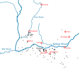
Description: Map of the middle Yellow River valley showing sites of the Erlitou culture (black) and locations of Xia dynasty capitals identified in traditional sources (red). Numbered capitals are the sequence of six capitals identified in the "current text" Bamboo Annals.
Title: Erlitou sites and Xia capitals
Credit: Own work design based on Chang, Kwang-chih (1986) The Archaeology of Ancient China, p. 319 ISBN: 0-300-03784-8. rivers from Natural Earth 1:10m Erlitou sites from Xu, Hong (2013) "The Erlitou Culture" Underhill, Anne P. , ed. , John Wiley & Sons, pp. 300–322 ISBN: 978-1-118-32578-0. p. 302, Figure 15.1. Xia capitals from Tan, Qixiang , ed. (1982) The Historical Atlas of China, 1, China Cartographic Publishing House Map 9–10.
Author: Kanguole
Usage Terms: Creative Commons Attribution-Share Alike 4.0
License: CC BY-SA 4.0
License Link: https://creativecommons.org/licenses/by-sa/4.0
Attribution Required?: Yes
Image usage
The following page links to this image:
