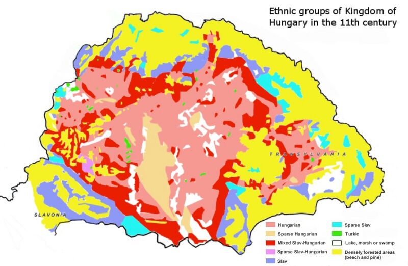
Image: Ethnic map of 11th century

Description: Ethnic map of Kingdom of Hungary in the 11th century based on place-names. ..."Although the historical study of place-names is not practised to the same extent in all countries, it is a recognized branch of historiography. It encompasses the etymology of geographical names as well as cultural and chronological variations in the naming of places. To facilitate their study of Hungarian place-names, István Kniezsa and Géza Bárczi developed an analytical framework that blends etymology, typology, and chronology. The validity of this triple approach has been amply demonstrated, thanks not only to the expertise of the two scholars but also to the peculiarity of Hungarian toponymy, which is readily distinguishable from that of any other culture. Most of the early Hungarian toponyms are derived from the names of people, clans, and ethnic groups, or from occupations, and used in the nominative case singular (e.g. Árpád, Megyer, Cseh [Czech], Ács [carpenter]). This type of toponymy appears in the earliest documents, dating from around 1000 AD. The pattern holds well into the 13th century — until the 1220s in western Hungary, and the 1270s in the eastern parts, including Transylvania..."(László Makkai, TRANSYLVANIA IN THE MEDIEVAL HUNGARIAN KINGDOM (896–1526), IN: Köpeczi Béla (General Editor), HISTORY OF TRANSYLVANIA Volume I. From the Beginnings to 1606, Distributed by Columbia University Press, New York, 2001, ISBN 0-88033-479-7) ."The verifiable name layers from the early period of the conquest were subjected to study in Hungary from the 1930s and 1940s, resulting in early historical place-name typologies (Moór 1936: 110–117, Kniezsa 1938, 1943, 1944, 1960, Kertész 1939: 33–39, 67–77, Kristó 1976), the results of which are still to this day largely accepted by the research community without reservation."[1]
Title: Ethnic map of 11th century
Credit: Own work Sources: The map "Magyarország népei a XI. században (tervezte: Kniezsa István és Glaser Lajos) [Peoples in Hungary in the 11th century (Designed by István Kniezsa and Lajos Glaser)]" in: Kniezsa István (1938, 2000). Magyarország népei a XI. században (Kiss Lajos bevezető tanulmányával) [Peoples in Hungary in the 11th Century (Introduction by Lajos Kiss)]. Lucidus Kiadó. ISBN 963-85954-3-4. (attached to the book) The map "Etnikai viszonyok a XI. században [Ethnic situation in the 11th century]" in: Bereznay, András (2011). Erdély történetének atlasza ["Atlas for the History of Transylvania"]. Méry Ratio. ISBN 978-80-89286-45-4. (page 51) (The map is based on a public domain map: http://commons.wikimedia.org/wiki/File:Hungary_13th_cent.png)
Author: Fakirbakir
Usage Terms: Creative Commons Attribution-Share Alike 3.0
License: CC BY-SA 3.0
License Link: https://creativecommons.org/licenses/by-sa/3.0
Attribution Required?: Yes
Image usage
The following page links to this image:

