
Image: Ethnolinguistic map of Burma 1972 en

Size of this PNG preview of this SVG file: 313 × 600 pixels. Other resolution: 125 × 240 pixels.
Original image (SVG file, nominally 1,063 × 2,037 pixels, file size: 70 KB)
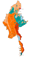
Description: Ethnolinguistic groups of Myanmar. Please note that city names are not modified (provided as they were in 1972). If you provide me with city and peoples names in your language, I’ll make a local version of this file for your Wikipedia. Bamar; Chin language speakers, Kachin, Lisu, Lahu; Karen; Chinese; Shan, Khamti; Thai; Wa, Palaung, Mon.
Title: Ethnolinguistic map of Burma 1972 en
Credit: Own work
Author: Kf8; Original author is U.S. Central Intelligence Agency.
Usage Terms: Creative Commons Zero, Public Domain Dedication
License: CC0
License Link: http://creativecommons.org/publicdomain/zero/1.0/deed.en
Attribution Required?: No
Image usage
The following page links to this image:

All content from Kiddle encyclopedia articles (including the article images and facts) can be freely used under Attribution-ShareAlike license, unless stated otherwise.