
Image: Eva-archaic-site-profile-tn1
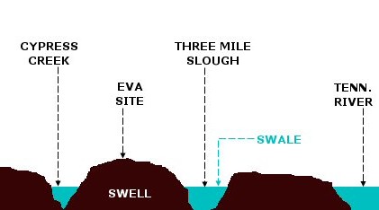
Description: A profile diagram of the floodplain upon which the Eva archaic site was located. Before the completion of Kentucky Dam inundated the site in 1944, the floodplain was characterized by a "swell-and-swale" topography. Swales are ancient river channels and tributary channels that are still filled with water, whereas swells are natural levees created by soil deposits from these ancient streams. The Tennessee River originally flowed through Three Mile Slough. This diagram is based on the description of the site given by Lewis and Lewis: Eva, an Archaic site, 1-4 (1961). NOT drawn to scale.
Title: Eva-archaic-site-profile-tn1
Credit: Own work
Author: Brian Stansberry
Usage Terms: Creative Commons Attribution 3.0
License: CC BY 3.0
License Link: https://creativecommons.org/licenses/by/3.0
Attribution Required?: Yes
Image usage
The following page links to this image:
