
Image: Extract from a Survey of the City, Harbour, Bay and Environs of Dublin on the same Scale as those of London, Paris & Rome by John Rocque
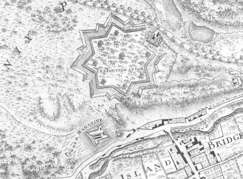
Description: Extract from "a Survey of the City, Harbour, Bay and Environs of Dublin on the same Scale as those of London, Paris & Rome". A map of Dublin by John Rocque (1709–1762) which is dated to 1757 . This extract highlights the area of the Phoenix Park in Dublin, immediately to the north of IslandBridge. The two principle subjects of this extract are: An earthen-works star fort (labelled "The Fortification" centre/top) - This fortification was commissioned by then Lord Lieutenant of Ireland Thomas Wharton (1648-1715) and designed by Thomas Burgh (1670–1730). Construction started in 1710, but the fortification was never completed. Note the incomplete section/gap on the north east "corner". The remaining earth-works were demolished in 1837.[1] A brick and limestone bastion fort (Labelled "Powder Magazine" centre-left/bottom) - This fortification was commissioned by then Lord Lieutenant of Ireland Lionel Sackville (1688-1765) and designed by John Corneille. Construction started in 1734/1735. The resulting Magazine Fort still stands in Dublin's Phoenix Park
Title: Extract from a Survey of the City, Harbour, Bay and Environs of Dublin on the same Scale as those of London, Paris & Rome by John Rocque
Credit: Bibliothèque nationale de France
Author: John Rocque (1709-1762)
Usage Terms: Public domain
License: Public domain
Attribution Required?: No
Image usage
The following page links to this image:
