
Image: Fes walls history 2 - early-mid 13th century (Almohad period)

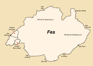
Description: Map 2 of 5, showing Fes after the construction of the Almohad walls and before the construction of Fes Jdid, early and mid-13th century. Modified map based on original map "Fes sous les Almohades.PNG" by Omar-toons. Changes include updates to spelling to be consistent with maps and names in main source (below). Names of gates which date to the Almohad period have been added. To reduce clutter and distractions, I've decided to forego the grey outlines of future walls which were present in the original file. Significant changes have been made to the western part of the map around Kasbah Bou Jeloud, as I redrew this part by following the outline of the western Fes el-Bali walls that are shown in the maps from the sources below. As a further note: it's not clear that any authors reasonably know what this part of the city walls exactly looked like in the Almohad period, as there's been a lot of construction in the area since then, so this part of the map can be interpreted as a tentative reconstruction that's probably biased towards the modern-day geography of the area. Some Almohad-era monuments have survived in the area though (e.g. the Bou Jeloud Mosque and Bab Mahrouk), so the general location of things is still known. Sources: 1) Le Tourneau, Roger (1949). "Fès avant le protectorat: étude économique et sociale d'une ville de l'occident musulman". See map on p.55 for general outline. See p. 117 and 119 for the shape of the Kasbah Bou Jeloud in particular, and p. 119 and 127 for the outline of the wall to the south of the kasbah in particular. 2) A copy of the same maps, as well as other useful maps where the outlines of the western well are a little more distinct, can be accessed in this UNESCO report (see page 4 and after in Volume 2, which is on the 49th page of the pdf file): https://unesdoc.unesco.org/ark:/48223/pf0000039605?posInSet=17&queryId=N-EXPLORE-cad3fb24-479f-4d70-bac6-6a01dc836092 )
Title: Fes walls history 2 - early-mid 13th century (Almohad period)
Credit: Wiki Commons
Author: Base map: Omar-toons Major modifications: R Prazeres
Usage Terms: Creative Commons Attribution-Share Alike 4.0
License: CC BY-SA 4.0
License Link: https://creativecommons.org/licenses/by-sa/4.0
Attribution Required?: Yes
Image usage
The following page links to this image:

.png)