
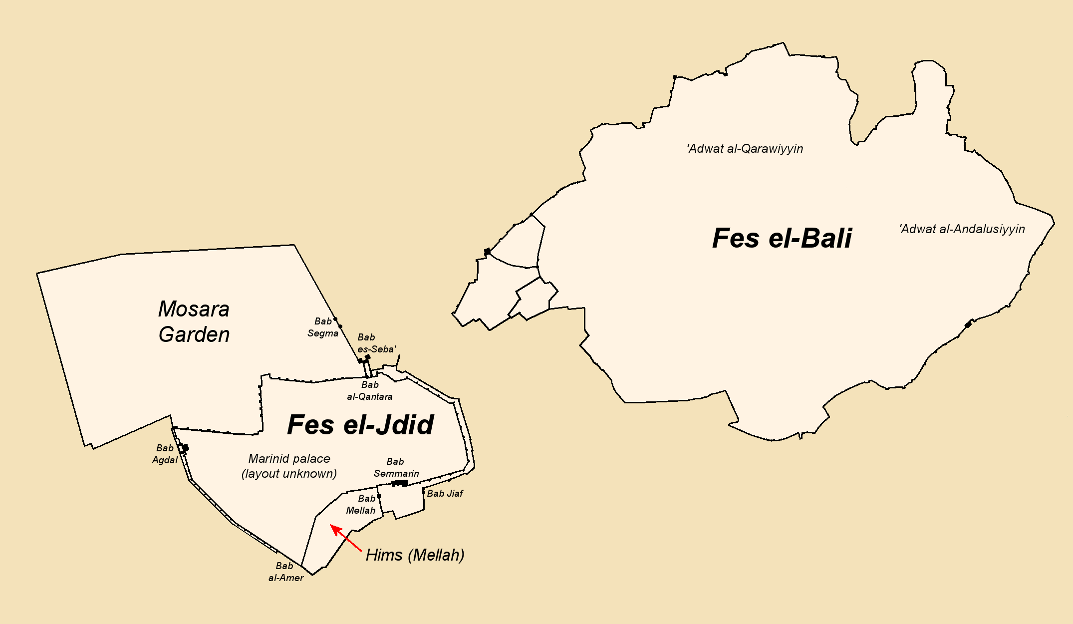
Image: Fes walls history 3 - late 14th or 15th century (Marinid period)
Description: Map 3 of 5, showing Fes in the late Marinid period, late 14th century or 15th century. New map based on original map "Plan Fes Merinides.PNG" by Omar-toons, but with major changes and new work added. Changes include updates to spelling to be consistent with maps and names in main source (below). Names of gates and areas which date to the Marinid period have been added; while some names were left out in order to focus on the Marinid-period changes. To reduce clutter and distractions, I've decided to forego the grey outlines of future walls which were present in the original file. Significant changes have been made to the western part of the map around Kasbah Bou Jeloud, as I redrew this part by following the outline of the western Fes el-Bali walls that are shown in the maps from the sources below. Significant changes have been made to the Fes Jdid walls, including, but not limited to: redrawing the walls of the Mellah to reflect the sources, illustrating the Marinid double walls and their gates and fortifications, removing the Dar al-Makhzen walls (because those were the present-day walls and the form of the original palaces is not known), and adding the walled Mosara Garden to the north. Further note: Bressolette and Delaroziere's work, which focuses on Fes Jdid and includes many maps, was crucial here and offers important details that aren't clear elsewhere, though I still consulted the other sources to help. Google Earth was of limited help too for some details. Bressolette and Delaroziere's articles should be accessible at the website of Hespéris-Tamuda, although access is sometimes unreliable. There's also a posthumously-published book compiling Bressolette's writings, called "À la découverte de Fès", L'Harmattan, 2016 I think. Sources: Le Tourneau, Roger (1949). "Fès avant le protectorat: étude économique et sociale d'une ville de l'occident musulman". See especially p. 96, 99, and 103 for Fes Jdid. A copy of the same maps, as well as other useful maps where the outlines of the western well are a little more distinct, can be accessed in this UNESCO report (see page 4 and after): https://unesdoc.unesco.org/ark:/48223/pf0000039605?posInSet=17&queryId=N-EXPLORE-cad3fb24-479f-4d70-bac6-6a01dc836092 ) Bressolette, Henri; Delaroziere, Jean (1983). "Fès-Jdid de sa fondation en 1276 au milieu du XXe siècle". Hespéris-Tamuda. XX–XXI: 245–318. Bressolette, Henri; Delarozière, Jean (1978). "El Mosara, jardin royal des Mérinides". Hespéris-Tamuda: 51–61.
Title: Fes walls history 3 - late 14th or 15th century (Marinid period)
Credit: Wiki Commons
Author: Base map: Omar-toons Major modifications: R Prazeres
Usage Terms: Creative Commons Attribution-Share Alike 4.0
License: CC BY-SA 4.0
License Link: https://creativecommons.org/licenses/by-sa/4.0
Attribution Required?: Yes
Image usage
The following page links to this image:

.png)