
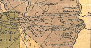
Image: Fort Bainbridge and Decatur

Size of this preview: 800 × 427 pixels. Other resolutions: 320 × 171 pixels | 1,380 × 736 pixels.
Original image (1,380 × 736 pixels, file size: 166 KB, MIME type: image/jpeg)
Description: 1830 map showing the location of Forts Decatur and Bainbridge and their location on stage routes.
Title: Fort Bainbridge and Decatur
Credit: https://digital.archives.alabama.gov/digital/collection/maps/id/66
Author: Henry Schenck Tanner
Usage Terms: Public domain
License: Public domain
Attribution Required?: No
Image usage
The following 2 pages link to this image:

All content from Kiddle encyclopedia articles (including the article images and facts) can be freely used under Attribution-ShareAlike license, unless stated otherwise.