
Image: Fort Lyon Diagram

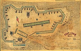
Description: The map by Sneden, Robert Knox, 1832-1918, is a close up drawing of Fort Lyon located on Eagle Hill in Alexandria, Virginia. Shows the fort's defenses, including abatis, ditches, salients, sally port, and bomb proof.
Title: Fort Lyon Diagram
Credit: This map is available from the United States Library of Congress's National Digital Library Program under the digital ID gvhs01.vhs00285. This tag does not indicate the copyright status of the attached work. A normal copyright tag is still required. See Commons:Licensing for more information.
Author: Robert Knox Sneden
Permission: This image is a work of a U.S. military or Department of Defense employee, taken or made as part of that person's official duties. As a work of the U.S. federal government, the image is in the public domain in the United States.
Usage Terms: Public domain
License: Public domain
Attribution Required?: No
Image usage
The following 2 pages link to this image:
