
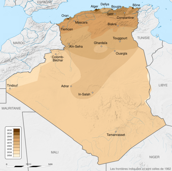
Image: French Algeria evolution 1830-1962 map-fr

Description: French Algeria evolution map, from 1830 to 1962. Scale: 1:6,800,000 (precision: 1,700 m) Equirectangular projection WGS84 datum Central meridian: 001° 39' E Standard parallel: 27° 31' 30" N Geographic limits of the map: Top: 37° 48' N Bottom: 18° 15' N Left: 009° 27' W Right: 012° 45' E
Title: French Algeria evolution 1830-1962 map-fr
Credit: Background: File:Algeria_location_map.svg NGDC World Data Bank II (public domain) NGDC GSHHS Relief: NASA Shuttle Radar Topography Mission (SRTM3 v.2) (public domain) Reference for the boundaries: SGIIAR (Système de Gestion Intégré de l'Information Agricole et Rurale of Algeria). Evolution: 1830-1930: File:Algérie 1830-1930.JPG 1830-1857: Henri Blet (1946) Histoire de la colonisation française : Les étapes d'une renaissance coloniale, 1789-1870, 2, Paris: Arthaud, pp. 136−137 1830-1930: Xavier Yacono (1993) Histoire de l'Algérie de la fin de la Régence turque à l'insurrection de 1954, Paris: Éditions de l'Atlanthrope, p. 262 ISBN: 2-86442-032-6. 1830-1930: Commandant P. Pollacchi (1930) Les progrès de la pacification française, Collection du Comité Métropolitain du Centenaire de l'Algérie 1956: File:Algeria-Libya boundary.jpg
Author: Sémhur
Usage Terms: Creative Commons Attribution-Share Alike 4.0
License: CC BY-SA 4.0
License Link: https://creativecommons.org/licenses/by-sa/4.0
Attribution Required?: Yes
Image usage
The following page links to this image:
