
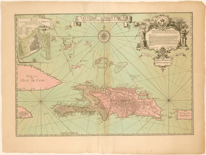
Image: Frezier Map of S. Domingue

Description: Map of Hispaniola with the French part, or Saint Domingue, present-day Haiti, in light pink and the Spanish part, or present-day Santo Domingo, hand-colored in dark pink. Map also includes portions of Cuba, Jamaica, Puerto Rico and all of the islands of the Turks and Caicos and portions of the Bahamas. Includes scales, text, and inset map at upper left hand corner. Relief shown pictorially. Soundings included. Decorative cartouche includes two women representing astronomy and navigation hold a globe, compass and paper, and telescope. Also includes windheads, royal coat of arms of France, and palm trees.
Title: Frezier Map of S. Domingue
Credit: https://jcb.lunaimaging.com/luna/servlet/detail/JCBMAPS~1~1~6418~115900216:Isle-de-S--Domingue-et-débouquemens?sort=normalized_date%2Cfile_name%2Csource_author%2Csource_title
Author: Amédée François Frézier
Usage Terms: Creative Commons Attribution-Share Alike 4.0
License: CC BY-SA 4.0
License Link: https://creativecommons.org/licenses/by-sa/4.0
Attribution Required?: Yes
Image usage
The following page links to this image:
