
Image: FumaroleButte USGS
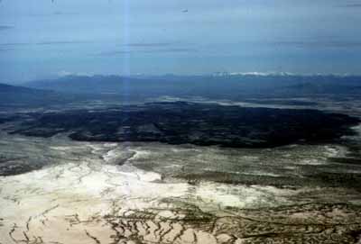
Description: USGS description: Fumarole Butte is a basaltic flow erupted during Pleistocene time. It is a basaltic example of the bimodal basalt-rhyolite volcanism that accompanied basin-range faulting during Miocene to present time. The butte is located about 20 miles southeast of Spor Mountain and can be accessed by road along the east side, from the paved highway connecting Spor Mountain to route 50. A detailed geologic map of the butte and surrounding Lake Bonneville deposits was made by Galyardt and Rush (1981). This is an aerial view of Fumarole Butte looking northeast; the snow-capped mountains on the skyline are the Oquirrh Range.
Title: FumaroleButte USGS
Credit: USGS report ofr-98-0524 [1]
Author: USGS
Usage Terms: Public domain
License: Public domain
Attribution Required?: No
Image usage
The following page links to this image:
