
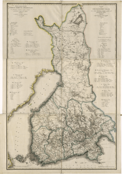
Image: General Map of the Grand Duchy of Finland. Indicating Postal Roads, Stations and the Distance in Versts Between Them- According to the Latest Verified Data in St. Petersburg in 1825 WDL353

Description: This 1825 map of the Grand Duchy of Finland is from a larger work, Geographical atlas of the Russian Empire, the Kingdom of Poland, and the Grand Duchy of Finland (Geograficheskii atlas Rossiiskoi imperii, tsarstva Pol'skogo i velikogo kniazhestva Finliandskogo), containing 61 maps of the Russian Empire. Compiled and engraved by Colonel V. P. Piadyshev, it reflects the detailed mapping carried out by Russian military cartographers in the first quarter of the 19th century. The map shows population centers (five gradations by size), fortresses, redoubts, postal courtyards and stations, roads (four types), and provincial and district borders. Distances are shown in versts, a Russian measure, now no longer used, equal to 1.0668 kilometers. Legends and place names are in Russian and Swedish. The territory depicted on the map roughly corresponds to that of present-day Finland. Finland was part of Sweden until 1809, when it became a Grand Duchy within the Russian Empire. In 1917 it declared its independence from Russia.
Title: General Map of the Grand Duchy of Finland. Indicating Postal Roads, Stations and the Distance in Versts Between Them: According to the Latest Verified Data in St. Petersburg in 1825
Credit: http://dl.wdl.org/353.png Gallery: http://www.wdl.org/en/item/353/
Author: Piadyshev, Vasiliĭ Petrovich
Usage Terms: Public domain
License: Public domain
Attribution Required?: No
Image usage
The following page links to this image:
