
Image: Genesee County NY map

Size of this PNG preview of this SVG file: 800 × 474 pixels. Other resolution: 320 × 190 pixels.
Original image (SVG file, nominally 1,450 × 860 pixels, file size: 525 KB)
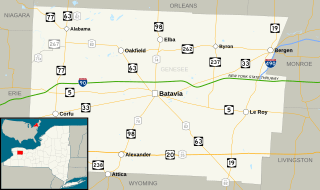
Description: Map of Genesee County, New York. Base map made in Quantum GIS using GIS data from the United States Census Bureau (TIGER) and the Federal Highway Administration (NHPN), and enhanced using Inkscape. This map uses public domain SVG route markers available on Wikimedia Commons.
Title: Genesee County NY map
Credit: Own work This graphic was created with QGIS This vector image was created with Inkscape.
Author: TwinsMetsFan
Usage Terms: Creative Commons Attribution-Share Alike 3.0
License: CC BY-SA 3.0
License Link: http://creativecommons.org/licenses/by-sa/3.0
Attribution Required?: Yes
Image usage
There are no pages that link to this image.

All content from Kiddle encyclopedia articles (including the article images and facts) can be freely used under Attribution-ShareAlike license, unless stated otherwise.