
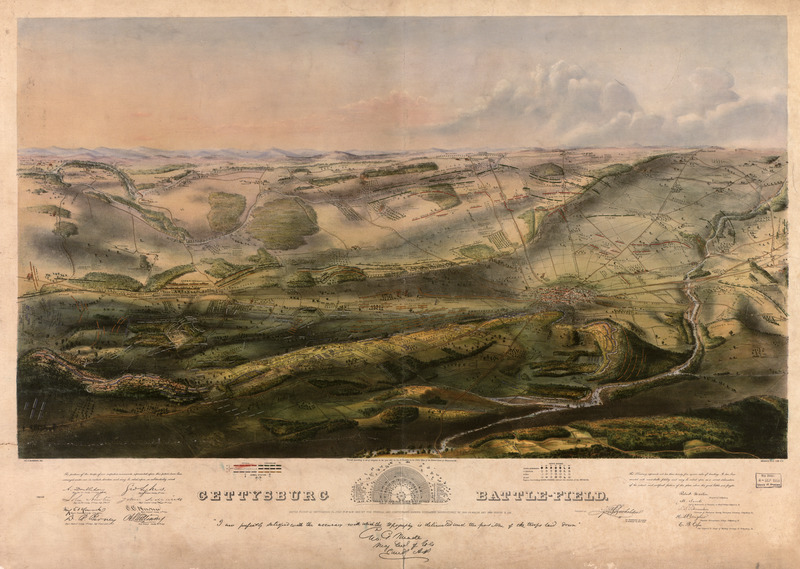
Image: Gettysburg battle-field Battle fought at Gettysburg Pa
Description: Title: Gettysburg battle-field. Battle fought at Gettysburg, Pa., July 1st, 2d & 3d, 1863 by the Federal and Confederate armies, commanded respectively by Genl. G. G. Meade and Genl. Robert E. Lee / Contributor Names: Bachelder, John B. (John Badger), 1825-1894. Created / Published: Boston and New York : Jno. B. Bachelder, c1863. Subject Headings Gettysburg, Battle of, Gettysburg, Pa., 1863--Maps Gettysburg Region (Pa.)--Maps United States--Pennsylvania--Gettysburg Region Notes LC Civil War Maps (2nd ed.), 322 Inset: Plan of the Soldiers National Cemetery. Uncolored. 6 x 13 cm. Bears a "Proof" mark in the lower left corner. Endorsed (facsim.): "I am perfectly satisfied with the accuracy with which the topography is delineated and the position of the troops laid down." [Signed] Geo. G. Meade, Maj. Gen. of Vols. comd. A. P. The reproduced signatures of A. Doubleday, John Newton, Winf. St. Hancock, D.B. Birney, Geo. Sykes, John Sedgwick, O. O. Howard, and A. S. Williams appear below the following statement: The positions of the troops of our respective commands represented upon this picture have been arranged under our immediate direction and may be relied upon as substantially corrct. Colored bird's-eye view showing the topography of the battlefield by the perspective of the drawing, shading and coloring. Drainage, vegetation, roads and streets, railroads, bridges, houses and names of residents, fences, points of interest on the battlefield, including designations of places where officers were killed or wounded, are indicated. The locations of the corps, divisions, brigades, etc. of both armies, with the names of commanding officers, are given in detail. Badge symbols are used to identify the Federal corps. The Library has 1864, 1865, and 1866 editions of the Key to Bachelder's Isometrical Drawing of the Gettysburg Battle-field, with a Brief Description of the Battle. This 10- or 12-page work, published in New York by C. A. Alvord, apparently was intended to accompany the print. Lower left half of view is torn. Description derived from published bibliography. Available also through the Library of Congress web site as raster image. Medium: 1 view, hand col., 53 x 92 cm. Call Number: G3824.G3S5 1863 .B321 Repository: Library of Congress Geography and Map Division Washington, D.C. 20540-4650 dcu Digital Id: g3824g cw0322000 http://hdl.loc.gov/loc.gmd/g3824g.cw0322000 Library of Congress Catalog Number: 2007630421 Other Formats MARCXML Record MODS Record Dublin Core Record Catalog Record: http://lccn.loc.gov/2007630421
Title: Gettysburg battle-field Battle fought at Gettysburg Pa
Credit: This map is available from the United States Library of Congress's Geography & Map Division under the digital ID g3824g.cw0322000. This tag does not indicate the copyright status of the attached work. A normal copyright tag is still required. See Commons:Licensing for more information.
Author: John B. Bachelder
Usage Terms: Public domain
License: Public domain
Attribution Required?: No
Image usage
The following page links to this image:
