
Image: Grand Canyon DEIS Aerial Photo Pollux Temple

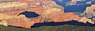
Description: This aerial photo is a view from one of the routes in the National Park Service (NPS) Preferred Alternative within the Draft Environmental Impact Statement (EIS), Special Flight Rules Area in the Vicinity of Grand Canyon National Park (GCNP), illustrating the high quality scenic views and grandeur of GCNP. This is the view as the aircraft leaves the canyon and begins to fly over the South Rim forest. Pollux Temple is centered. Castor Temple in upper left. Camera pointed northwest. NPS Photo
Title: Grand Canyon DEIS Aerial Photo Pollux Temple
Credit: File:Grand Canyon DEIS Aerial Photo Pollux and Diana Temples (5476511741).jpg
Author: Grand Canyon National Park
Usage Terms: Creative Commons Attribution 3.0
License: CC BY 3.0
License Link: https://creativecommons.org/licenses/by/3.0
Attribution Required?: Yes
Image usage
The following page links to this image:
