
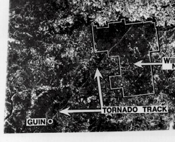
Image: Guin, Alabama, 1974 tornado damage path ERTS-1 satellite image (cropped)
No higher resolution available.
Guin,_Alabama,_1974_tornado_damage_path_ERTS-1_satellite_image_(cropped).jpg (341 × 276 pixels, file size: 81 KB, MIME type: image/jpeg)
Description: Satellite view of a damage path from an F5 tornado that hit Guin, Alabama, on April 3, 1974
Usage Terms: Public domain
Image usage
The following page links to this image:

All content from Kiddle encyclopedia articles (including the article images and facts) can be freely used under Attribution-ShareAlike license, unless stated otherwise.
.jpg)