
Image: Han Civilisation

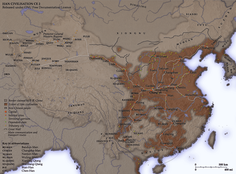
Description: Notes Created and copyright (2006) by Yeu Ninje. Released under the GNU FDL. This map shows the world as was known to en:Han Dynasty en:China in en:2 CE. The shaded areas show the extent of Han civilisation. I've based this on the existence of settlements under direct Han political authority or military control according to Tan Qixiang (ed.), Zhongguo lishi ditu (中国历史地图集; 1982). The international boundary shown is the border claimed by the en:People's Republic of China. Compare the territories of the historical Han dynasty and the territories over which the modern Chinese state claims sovereignty. Territorial garrisons The headquarters of chief commandants (都尉) are shown in yellow. Chief commandants commanded territorial garrisons and were responsible for the supression of local armed threats and supervision of recruitment for military service. Note that these were concentrated on the frontiers, especially on the northern border region. When in the interior of the Han empire, they were often placed near en:iron or en:salt industries, or on important communication routes. Dependent states (屬國) are shown in green. These were usually mixed settlements of Chinese and Xiongnu or more commonly, en:Qiang, under Han administration. The Great Wall During most of the Western Han period, the en:Great Wall served as a line of demarcation between Han and non-Chinese peoples, most notable of whom were the en:Xiongnu. The line of the Great Wall was extended by Emperor Wu along the en:Gansu corridor (the commanderies based at Dunhuang, Lufu, Lude and Guzang). This, along with walls north of the great loop of the en:Yellow River (beyond Wuyuan), provided the front line defences against the Xiongnu. A second line was maintained along the old Qin wall (the one that passes close to Fushi and Didao), which was important even into the en:1st century. Both the lines of the Great Wall and Yellow River are based on Tan Qixiang (ed.), Zhongguo lishi ditu (中国历史地图集; 1982). Note that the Yellow River is considerably to the north of its present flow. Routes of communication The broad outline of communication and transport routes from the capital en:Chang'an is marked in white. These were based on en:Qin Dynasty imperial highways, Han roads (such as the Chang'an-Anyi-Taiyuan-Yu road) and navigable riverways (such as the Chenliu and Shouchun route). The long road extending west from Chang'an to the "en:Western Regions" is often known as the en:Silk Road. These are based in part on the reconstruction of early Chinese roads and waterways by en:Joseph Needham in Science and Civilisation, Vol. IV, (1954), and the additions of en:Rafe de Crespigny in Generals of the South (1992). The northern and southern routes of the Silk Road in the Western Regions is based on Map 16 in Cambridge History of China, vol. 1, (1986). The Western Regions From the end of the en:2nd century BC, Han China fought with the Xiongnu over control of the Western Regions. By the time that they established the office of Protector General of the Western Regions (at Wulei) in en:60 BC or en:59 BC, the entire region was dominated by the Chinese. Tributary city-states, in light orange, sent periodic tribute to Chang'an and were rewarded by the Han court. Transliteration Names of non-Chinese peoples and states have been purposely left with their Chinese names (e.g. Dayuan instead of en:Fergana; Gaogouli instead of en:Goguryeo) to reflect the fact that our knowledge of participants in the Han world order comes almost exclusively from Chinese sources. Chinese names are transliterated by en:pinyin (e.g. Dayuan instead of Ta-yuan). Transliteration of non-Chinese peopes and states follows the pronunciation guides given in the Hou Han shu. They often diverge from the Mandarin pronunciations which are now standard: 婼羌 Er-Qiang; 鄯善 Shanshan; 且末 Jumo; 小宛 Xiao-Yuan; 精絕 Jingjue; 戎盧 Ronglu; 扜彌 Wumi; 渠勒 Jule; 于闐 Yutian; 皮山 Pishan; 烏秅 Wucha; 西夜 Xiye (Xiyi); 蒲 Pu; 依耐 Yinai; 無雷 Wulei; 難兜 Nandou; 罽賓 Jibin; 烏弋山離 Wuyishanli; 安息 Anxi; 大月氏 Da-Yuezhi; 康居 Kangju; 大宛 Da-Yuan; 桃槐 Taohui; 休循 Xiuxun; 捐毒 Juandu; 莎車 Shaju; 疏勒 Shule; 尉頭 Weitou; 龜茲 Qiuci; 姑墨 Gumo; 焉耆 Yanqi. Related images Qin empire (210 BC) Ming civilisation (1580)
Title: Han Civilisation
Credit: Own work compiled from and based on the sources stated above
Author: User Yeu Ninje on en.wikipedia
Permission: Yeu Ninje at the English language Wikipedia, the copyright holder of this work, hereby publishes it under the following license: Permission is granted to copy, distribute and/or modify this document under the terms of the GNU Free Documentation License, Version 1.2 or any later version published by the Free Software Foundation; with no Invariant Sections, no Front-Cover Texts, and no Back-Cover Texts. A copy of the license is included in the section entitled GNU Free Documentation License.http://www.gnu.org/copyleft/fdl.htmlGFDLGNU Free Documentation Licensetruetrue This file is licensed under the Creative Commons Attribution-Share Alike 3.0 Unported license. Attribution: Yeu Ninje at the English language Wikipedia You are free: to share – to copy, distribute and transmit the work to remix – to adapt the work Under the following conditions: attribution – You must attribute the work in the manner specified by the author or licensor (but not in any way that suggests that they endorse you or your use of the work). share alike – If you alter, transform, or build upon this work, you may distribute the resulting work only under the same or similar license to this one. This licensing tag was added to this file as part of the GFDL licensing update.http://creativecommons.org/licenses/by-sa/3.0/CC-BY-SA-3.0Creative Commons Attribution-Share Alike 3.0truetrue
Usage Terms: Creative Commons Attribution-Share Alike 3.0
License: CC-BY-SA-3.0
License Link: http://creativecommons.org/licenses/by-sa/3.0/
Attribution Required?: Yes
Image usage
The following page links to this image:
