
Image: Hatepe.North.Island.NZ

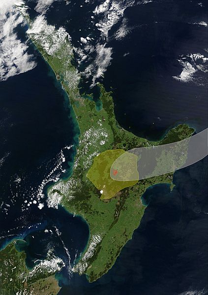
Description: White shaded area 10cm ash fall, yellow shaded area are ignimbrite from pyroclastic flow (both highly approximate) , light red collapse crater and red vents of Hatepe eruption, Taupo Annotations based on: INTRODUCTION TO TEPHRA-DERIVED SOILS AND FARMING, WAIKATO-BAY OF PLENTY, NORTH ISLAND, NEW ZEALAND. (1 June 2021). "Volcanic Unrest at Taupō Volcano in 2019: Causes, Mechanisms and Implications". Geochemistry, Geophysics, Geosystems 22 (6): 1–27. DOI:10.1029/2021GC009803.This image is a derivative work of the following images: File:Satellite image of New Zealand in December 2002.jpgPublic domainPublic domainfalsefalse This image is in the public domain because it is a screenshot from NASA’s globe software World Wind using a public domain layer, such as Blue Marble, MODIS, Landsat, SRTM, USGS or GLOBE. العربيَّة | English | فارسی | français | עברית | македонски | മലയാളം | Nederlands | русский | 中文(中国大陆) | +/−
Title: Hatepe.North.Island.NZ
Credit: Own work
Author: ChaseKiwi
Usage Terms: Public domain
License: Public domain
Attribution Required?: No
Image usage
The following page links to this image:
