
Image: Hualālai Threat Mapping
No higher resolution available.
Hualālai_Threat_Mapping.gif (291 × 318 pixels, file size: 20 KB, MIME type: image/gif)
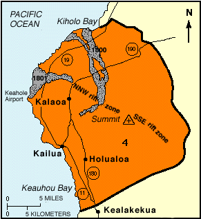
Description: Threat level map of Hualalai. On a scale of 1 to 9 it is listed as level 4. The two grey areas are volcanic eruptions dating from 1801.
Title: Hualālai Threat Mapping
Credit: http://pubs.usgs.gov/gip/hazards/fig23.gif (direct link) http://pubs.usgs.gov/gip/hazards/hualalai.html (usage)
Author: USGS
Permission: PD-USGov-USGS
Usage Terms: Public domain
License: Public domain
Attribution Required?: No
Image usage
The following page links to this image:

All content from Kiddle encyclopedia articles (including the article images and facts) can be freely used under Attribution-ShareAlike license, unless stated otherwise.