
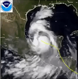
Image: Hurricane Gert visible satellite loop
No higher resolution available.
Hurricane_Gert_visible_satellite_loop.gif (266 × 270 pixels, file size: 2.81 MB, MIME type: image/gif, looped, 54 frames, 5.4 s)
Description: A satellite loop capture from September 18–21 showing Hurricane Gert of 1993 crossing the Gulf, making landfall on the east Mexican coast, and traversing land.
Title: Hurricane Gert visible satellite loop
Credit: http://www.ssd.noaa.gov/goes/east/
Author: NOAA (page is updated every week; its archives hold only up to 4 weeks of information. Hence, the site no longer hosts the animation.)
Usage Terms: Public domain
License: Public domain
Attribution Required?: No
Image usage
The following page links to this image:

All content from Kiddle encyclopedia articles (including the article images and facts) can be freely used under Attribution-ShareAlike license, unless stated otherwise.