
Image: I35WBridgeMinneapolisSatellite2004

Size of this preview: 600 × 600 pixels. Other resolutions: 240 × 240 pixels | 2,048 × 2,048 pixels.
Original image (2,048 × 2,048 pixels, file size: 877 KB, MIME type: image/jpeg)
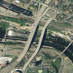
Description: Aerial view of the I-35W Mississippi River Bridge in Minneapolis, Minnesota, and the surrounding area. The bridge collapsed in August, 2007. Just to its right is the older 10th Avenue Bridge, and at the far right is the Northern Pacific Bridge Number 9. At the left is the Lower Saint Anthony Falls Dam.
Title: I35WBridgeMinneapolisSatellite2004
Credit: USGS EDC Urban Area Orthography 0.3m photo
Author: U.S. Geological Survey
Permission: Public domain
Usage Terms: Public domain
License: Public domain
Attribution Required?: No
Image usage
The following page links to this image:

All content from Kiddle encyclopedia articles (including the article images and facts) can be freely used under Attribution-ShareAlike license, unless stated otherwise.