
Image: ISS018-E-028898 lrg
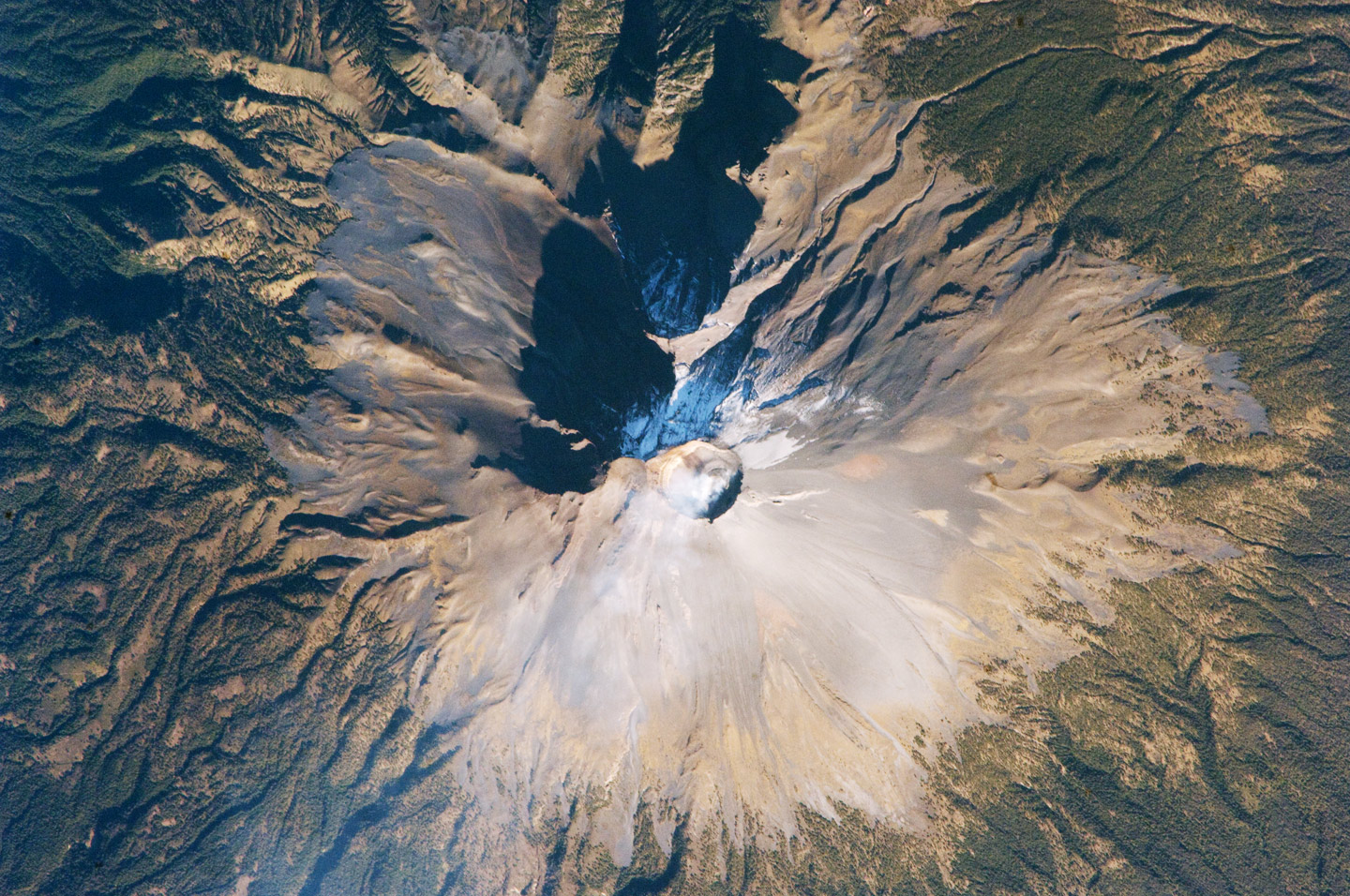
Description: Volcano Popocatepetl, a large strato volcano located approximately 70 kilometers southeast of Mexico City, is considered by many volcanologists to be “the planet’s riskiest volcano.” The volcano warrants this distinction because of how close it is to one of the most densely populated mega cities on Earth: near 23 million people lived in Mexico City in 2009. The variety of potential volcanic hazards at Popocatepetl is also considerable, including explosive eruptions of ash, pyroclastic flows (hot, fluid avalanches of rock fragments and gas), and debris avalanches. This detailed astronaut photograph of the summit crater of Popocatepetl (image center) also highlights Ventorillo and Noroccidental Glaciers. Together with the ice on nearby Iztaccíhuatl Volcano and Pico de Orizaba (Mexico’s highest peak and the highest volcano in North America), Popocatepetl’s glaciers are the only mountain glaciers in tropical North America. The glaciers create yet another volcanic hazard: dangerous mudflows, or lahars, if the ice were to melt during an eruption. At the time this image was taken, steam and ash plumes were observed at the volcano. A faint white steam plume is visible against gray ash deposits on the eastern and southern flanks of the volcano. ISS Crew Earth Observations: ISS018-E-28898 Identification Mission ISS018 (Expedition 18) Roll E Frame 28898 Country or Geographic Name MEXICO Features POPOCATEPETL VOLCANO, SUMMIT CRATER Center Point Latitude 19.0° N Center Point Longitude -98.6° E Camera Camera Tilt 22° Camera Focal Length 800 mm Camera Nikon D2Xs Film 4288 x 2848 pixel CMOS sensor, RGBG imager color filter. Quality Percentage of Cloud Cover 0-10% Nadir What is Nadir? Date 2009-02-07 Time 15:05:24 Nadir Point Latitude 19.7° N Nadir Point Longitude -97.5° E Nadir to Photo Center Direction Southwest Sun Azimuth 119° Spacecraft Altitude 189 nautical miles (350 km) Sun Elevation Angle 26° Orbit Number 2557
Title: ISS018-E-028898 lrg
Credit: http://earthobservatory.nasa.gov/IOTD/view.php?id=37589&src=iotdrss
Author: Astronaut photograph ISS018-E-28898 was acquired on February 7, 2009, with a Nikon D2Xs digital camera fitted with an 800 mm lens, and is provided by the ISS Crew Earth Observations experiment and the Image Science & Analysis Laboratory, Johnson Space Center. The image was taken by the Expedition 18 crew. The image in this article has been cropped and enhanced to improve contrast. Lens artifacts have been removed. The International Space Station Program supports the laboratory to help astronauts take pictures of Earth that will be of the greatest value to scientists and the public, and to make those images freely available on the Internet. Additional images taken by astronauts and cosmonauts can be viewed at the NASA/JSC Gateway to Astronaut Photography of Earth. Caption William L. Stefanov, NASA-JSC.
Permission: http://earthobservatory.nasa.gov/ImageUse/
Usage Terms: Public domain
License: Public domain
Attribution Required?: No
Image usage
The following page links to this image:
