
Image: India-Pakistan Borderlands at Night

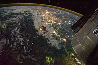
Description: Clusters of yellow lights on the Indo-Gangetic Plain reveal numerous cities large and small in this astronaut photograph of northern India and northern Pakistan. Of the hundreds of clusters, the largest are the capital cities of Islamabad, Pakistan, and New Delhi, India. (For scale, these metropolitan areas are approximately 700 kilometres apart.) The lines of major highways connecting the cities also stand out. More subtle, but still visible at night, are the general outlines of the towering and partly cloud-covered Himalayas to the north (image left).A striking feature is the line of lights, with a distinctly orange hue, snaking across the centre of the image. It appears to be more continuous and brighter than most highways in the view. This is the fenced and floodlit border zone between India and Pakistan. The fence is designed to discourage smuggling and arms trafficking. A similar fenced zone separates India’s eastern border from Bangladesh (not visible).This image was taken with a 16 mm lens, which provides the wide field of view, as the International Space Station (ISS) was tracking towards the south-east across India. The ISS crew took the image as part of a continuous series of frames, each with a one-second exposure time to maximize light collection. Unfortunately, this also causes blurring of some ground features.The distinct, bright zone above the horizon (visible at image top) is air-glow, a phenomena caused by excitation of atoms and molecules high in the atmosphere (above 80 kilometres) by ultraviolet radiation from the Sun. Part of the ISS Permanent Multipurpose Module and a solar panel array are visible at image right.
Usage Terms: Public domain
Image usage
The following page links to this image:
