
Image: Isle-of-hope-1780-map-ga1
No higher resolution available.
Isle-of-hope-1780-map-ga1.jpg (436 × 296 pixels, file size: 70 KB, MIME type: image/jpeg)
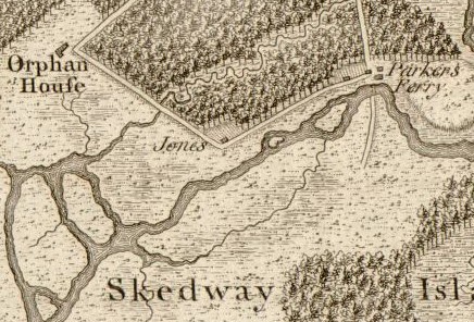
Description: Detail of the Skidaway Narrows from Archibald Campbell's 1780 "Sketch of the northern frontiers of Georgia, extending from the mouth of the River Savannah to the town of Augusta". The map was engraved by William Faden. The map shows George Whitefield's Bethesda Orphan House, the Wormsloe Plantation (labelled simply as "Jones" after Wormsloe's builder, Noble Jones), and the Isle of Hope-Skidaway Island ferry operated by Henry Parker.
Title: Isle-of-hope-1780-map-ga1
Credit: www.loc.gov
Author: Archibald Campbell
Usage Terms: Public domain
License: Public domain
Attribution Required?: No
Image usage
The following page links to this image:

All content from Kiddle encyclopedia articles (including the article images and facts) can be freely used under Attribution-ShareAlike license, unless stated otherwise.