
Image: Jacksonville-Palatka, FL-GA CSA
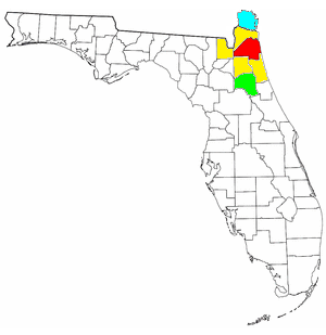
Description: Map of Jacksonville-Palatka, FL-GA Combined Statistical Area (CSA): Red: Duval County, Florida (City of Jacksonville, Florida for the most part) Yellow: surrounding counties included in Jacksonville, FL MSA Light Green: Putnam County, Florida (Palatka, FL µSA) Light Blue: Camden County, Georgia (St. Mary's, GA µSA)
Title: Jacksonville-Palatka, FL-GA CSA
Credit: I modified File:Jacksonville, Florida MSA.png, which had been previously modified by either Wapcaplet or Jdforrester, as well as myself, based on public domain map courtesy of The General Libraries, The University of Texas at Austin.
Author: Yassie
Permission: I have previously published the original image, File:Jacksonville, Florida MSA.png, under CC-BY-SA-3.0 license. I hereby publish this modified image under CC-BY-SA-3.0 license too.
Usage Terms: Creative Commons Attribution-Share Alike 3.0
License: CC BY-SA 3.0
License Link: https://creativecommons.org/licenses/by-sa/3.0
Attribution Required?: Yes
Image usage
There are no pages that link to this image.
