
Image: Japan-Archipelago-Outlined-Islands-Map

Size of this preview: 734 × 600 pixels. Other resolutions: 294 × 240 pixels | 2,012 × 1,644 pixels.
Original image (2,012 × 1,644 pixels, file size: 3.2 MB, MIME type: image/png)
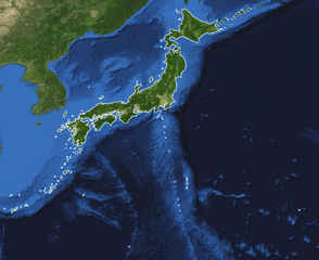
Description: This is a topography and bathymetry map of the Japanese archipelago with outlined islands. It shows the land and the seabed of Japan. All significant Japanese owned and controlled islands are outlined with a solid line such as Minami-Tori-Shima, Okinotorishima, Yonaguni and the Senkaku islands. The northern territories (kuril islands) and Takeshima have a dashed line.
Title: Japan-Archipelago-Outlined-Islands-Map
Credit: Blue Marble Next Generation W/ Topography and Bathymetry (July 1 - 31, 2004) https://visibleearth.nasa.gov/view.php?id=73751
Author: Credit: Reto Stöckli, NASA Earth Observatory
Usage Terms: Public domain
License: Public domain
Attribution Required?: No
Image usage
The following page links to this image:

All content from Kiddle encyclopedia articles (including the article images and facts) can be freely used under Attribution-ShareAlike license, unless stated otherwise.