
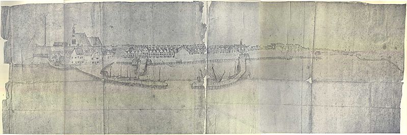
Image: Jasper Danckaerts - Map based on - New York from Brooklyn Heights - 1679

Size of this preview: 799 × 266 pixels. Other resolutions: 320 × 107 pixels | 3,000 × 999 pixels.
Original image (3,000 × 999 pixels, file size: 406 KB, MIME type: image/jpeg)
Description: Jasper Danckaerts - Map based on - New York from Brooklyn Heights - 1679
Title: Jasper Danckaerts - Map based on - New York from Brooklyn Heights - 1679
Credit: The Project Gutenberg eBook, Journal of Jasper Danckaerts, 1679-1680, by Jasper Danckaerts, Edited by Bartlett Burleigh James and J. Franklin Jameson, Translated by Henry C. Murphy - http://www.gutenberg.org/files/23258/23258-h/23258-h.htm
Author: Copied from a work by Jasper Danckaerts
Usage Terms: Public domain
License: Public domain
Attribution Required?: No
Image usage
The following page links to this image:

All content from Kiddle encyclopedia articles (including the article images and facts) can be freely used under Attribution-ShareAlike license, unless stated otherwise.