
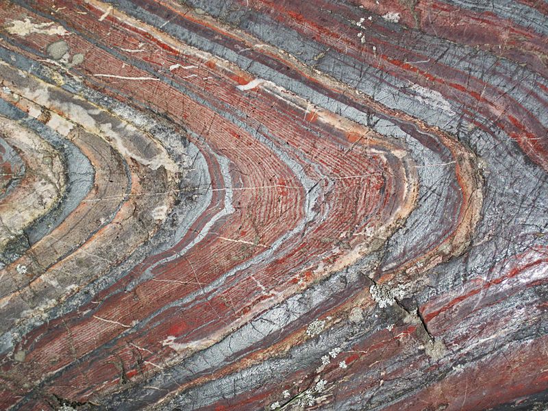
Image: Jaspilite banded iron formation, Soudan Underground State Park
Description: Glacially eroded outcrop of jaspilite banded iron formation in the Precambria of Minnesota. The Soudan Iron-Formation is a Neoarchean-aged banded iron formation (BIF) unit in the Vermilion Greenstone Belt of northeastern Minnesota, USA. Stratigraphically, the Soudan is considered to be the middle member of the Ely Greenstone. Metamorphosed pillow basalt successions occur above and below the iron-rich interval: - upper member of the Ely Greenstone - Soudan Iron-Formation member - lower member of the Ely Greenstone Radiometric dating of Ely Greenstone rocks (see Jahn & Murthy, 1975) indicate that the Soudan Iron-Formation is about 2.69 billion years old. The Soudan Iron-Formation was deposited in a deep-water environment and is closely associated with several types of volcanic rocks formed in an ancient island arc setting. As such, the unit is classified as an Algoma-type iron-formation. Superior-type iron-formations were deposited in relatively shallow water, continental shelf settings. The Soudan Iron-Formation is exposed in & around the town of Soudan, Minnesota at roadcuts, glacially-eroded outcrop knobs, surface mines, and underground mines. The best exposures are at Soudan Underground Mine State Park. The Soudan Mine targeted high-grade iron ore (specularite) for many decades and closed in the early 1960s. The site is now accessible to the public and underground tours are offered. Observed iron-rich lithologies in the Soudan Iron-Formation include specularite, jaspilite BIF, and magnetite BIF. The above photo is part of a glaciated knob of jaspilite BIF in Soudan Mine Park. The outcrop is glacially smoothed and striated. The rocks here are faulted and complexly folded. Folding occurred in two phases - some of it occurred during soft-sediment deformation events and subsequent structural folding occurred after the rocks were lithified. The light-colored layers are chert (= microcrystalline to cryptocrystalline quartzose sedimentary rock), the red layers are "jasper" (= hematite-rich chert), and the silvery-gray layers are magnetite-chert. A detailed description of this outcrop occurs in Huda et al. (2008). Stratigraphy: Soudan Iron-Formation member, Ely Greenstone, Vermilion Greenstone Belt, Neoarchean, ~2.69 Ga Locality: glaciated outcrop know adjacent to Stuntz Bay Road in Soudan Underground State Park, Soudan, northern St. Louis County, northeastern Minnesota, USA (47° 49' 14.82" North, 92° 14' 11.84" West) References cited: Huda et al. (2008) - Field Guide to the Volcanology, Structure, Alteration, and Mineralization of Archean Greenstone Belts in the Vicinities of Sturgeon Lake and Rainy River, Ontario and Lake Vermilion, Minnesota, October 5-12, 2008, Field Trip Guidebook. 209 pp. Jahn & Murthy (1975) - Rb-Sr ages of the Archean rocks from the Vermilion District, northeastern Minnesota. Geochimica et Cosmochimica Acta 39: 1679-1689.
Title: Jaspilite banded iron formation, Soudan Underground State Park
Credit: Jaspilite banded iron formation (Soudan Iron-Formation, Neoarchean, ~2.69 Ga; Stuntz Bay Road outcrop, Soudan Underground State Park, Soudan, Minnesota, USA) 53
Author: James St. John
Usage Terms: Creative Commons Attribution 2.0
License: CC BY 2.0
License Link: https://creativecommons.org/licenses/by/2.0
Attribution Required?: Yes
Image usage
The following 3 pages link to this image:
