
Image: Karte - Landungen auf Tulagi, Gavutu, Tanambogo

Size of this preview: 800 × 451 pixels. Other resolutions: 320 × 180 pixels | 891 × 502 pixels.
Original image (891 × 502 pixels, file size: 65 KB, MIME type: image/png)
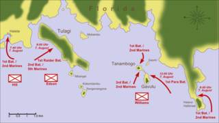
Description: Map in German language depicting the allied landings on Tulagi, Florida Island, Gavutu and Tanambogo (7 / 8 August 1942) during the Pacific War.
Title: Karte - Landungen auf Tulagi, Gavutu, Tanambogo
Credit: Own work based on: Mueller, Joseph N. (1992) (in English) Guadalcanal 1942 - The marines strike back, London, p. 27
Author: Memnon335bc
Usage Terms: Creative Commons Attribution 3.0
License: CC BY 3.0
License Link: https://creativecommons.org/licenses/by/3.0
Attribution Required?: Yes
Image usage
The following page links to this image:

All content from Kiddle encyclopedia articles (including the article images and facts) can be freely used under Attribution-ShareAlike license, unless stated otherwise.