
Image: Kasbah of Moulay Ismail with labels

Size of this preview: 504 × 600 pixels. Other resolutions: 202 × 240 pixels | 1,956 × 2,328 pixels.
Original image (1,956 × 2,328 pixels, file size: 122 KB, MIME type: image/png)
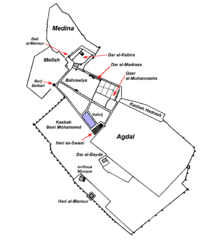
Description: Map of the Kasbah or Imperial City of Moulay Ismail, with notable elements identified. Map is based on the maps drawn by Marianne Barrucand in her 1980 book "L'architecture de la Qasba de Moulay Ismaïl à Meknès" and subsequently re-published or reused in other works.
Title: Kasbah of Moulay Ismail with labels
Credit: Own work
Author: Robert Prazeres
Usage Terms: Creative Commons Attribution-Share Alike 4.0
License: CC BY-SA 4.0
License Link: https://creativecommons.org/licenses/by-sa/4.0
Attribution Required?: Yes
Image usage
The following page links to this image:

All content from Kiddle encyclopedia articles (including the article images and facts) can be freely used under Attribution-ShareAlike license, unless stated otherwise.