
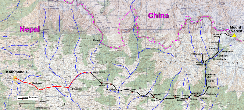
Image: Kathmandu to Mount Everest approach march, Bonington 1975

Description: NG 45-2 Mount Everest and NG 45-1 Katmandu. Tiles of the Map India and Pakistan 1:250,000. Series U502, U.S. Army Map Service, 1955 (1954 China) Cropping and annotation by uploader, own work. The red line shows the road existing in 1975 and the black line is the route taken by the 1975 British Mount Everest Southwest Face expedition as described in Bonington, Chris (1976) Everest the Hard Way, London: Hodder and Stoughton ISBN: 0340208333. . The base map shows the then (indeterminate) border so the annotation shows the contemporary border from the Times Atlas/ Google Maps.
Title: Kathmandu to Mount Everest approach march, Bonington 1975
Credit: http://www.lib.utexas.edu/maps/ams/india/ng-45-02.jpg http://www.lib.utexas.edu/maps/ams/india/ng-45-01.jpg http://www.lib.utexas.edu/maps/ams/india/nh-45-13.jpg http://www.lib.utexas.edu/maps/ams/china/txu-oclc-10552568-nh45-14.jpg
Author: U.S. Army Map Service
Usage Terms: Public domain
License: Public domain
Attribution Required?: No
Image usage
The following page links to this image:
