
Image: Kenton Commercial Historic District Map

Size of this preview: 799 × 599 pixels. Other resolutions: 320 × 240 pixels | 897 × 673 pixels.
Original image (897 × 673 pixels, file size: 252 KB, MIME type: image/png)
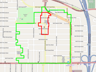
Description: Rough boundaries of in Portland, Oregon. The district (red) is shown within the larger Kenton Conservation District (green). The base map is from OpenStreetMap.org, which releases their data under a suitable license. Boundaries drawn by hand using images found here.
Title: Kenton Commercial Historic District Map
Credit: Own work
Author: Dudemanfellabra
Usage Terms: Creative Commons Attribution-Share Alike 3.0
License: CC BY-SA 3.0
License Link: https://creativecommons.org/licenses/by-sa/3.0
Attribution Required?: Yes
Image usage
The following page links to this image:

All content from Kiddle encyclopedia articles (including the article images and facts) can be freely used under Attribution-ShareAlike license, unless stated otherwise.