
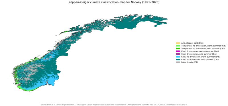
Image: Koppen-Geiger Map v2 NOR 1991–2020

Size of this PNG preview of this SVG file: 800 × 374 pixels. Other resolution: 320 × 150 pixels.
Original image (SVG file, nominally 1,816 × 850 pixels, file size: 4.68 MB)
Description: Köppen–Geiger climate classification map at 1-km resolution for Norway 1991–2020
Title: Koppen-Geiger Map v2 NOR 1991–2020
Credit: "High-resolution (1 km) Köppen-Geiger maps for 1901–2099 based on constrained CMIP6 projections". Scientific Data. DOI:10.1038/s41597-023-02549-6.
Author: Beck, H.E., McVicar, T.R., Vergopolan, N., Alexis, B., Lutsko, N.J., Dufour, A., Zeng, Z., Jian, X., van Dijk, A.I.J.M., Miralles, D.G.
Usage Terms: Creative Commons Attribution 4.0
License: CC BY 4.0
License Link: https://creativecommons.org/licenses/by/4.0
Attribution Required?: Yes
Image usage
The following page links to this image:

All content from Kiddle encyclopedia articles (including the article images and facts) can be freely used under Attribution-ShareAlike license, unless stated otherwise.