
Image: Krabbenkreek-Zeeland-2020-Luka-Peternel

Size of this preview: 718 × 599 pixels. Other resolutions: 288 × 240 pixels | 4,371 × 3,648 pixels.
Original image (4,371 × 3,648 pixels, file size: 4.29 MB, MIME type: image/jpeg)
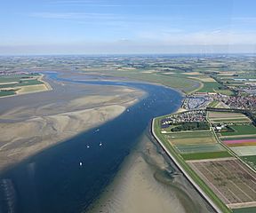
Description: Aerial view of Krabbenkreek in Zeeland. The view is facing east. The town of Sint Annaland is visible in the right of the photo, while the town of Sint Philipsland is in the top-left.
Title: Krabbenkreek-Zeeland-2020-Luka-Peternel
Credit: Own work
Author: Luka Peternel
Usage Terms: Creative Commons Attribution-Share Alike 4.0
License: CC BY-SA 4.0
License Link: https://creativecommons.org/licenses/by-sa/4.0
Attribution Required?: Yes
Image usage
The following 2 pages link to this image:

All content from Kiddle encyclopedia articles (including the article images and facts) can be freely used under Attribution-ShareAlike license, unless stated otherwise.