
Image: Kwajalein Atoll 2003-02-07 - Landsat 7 - 30m
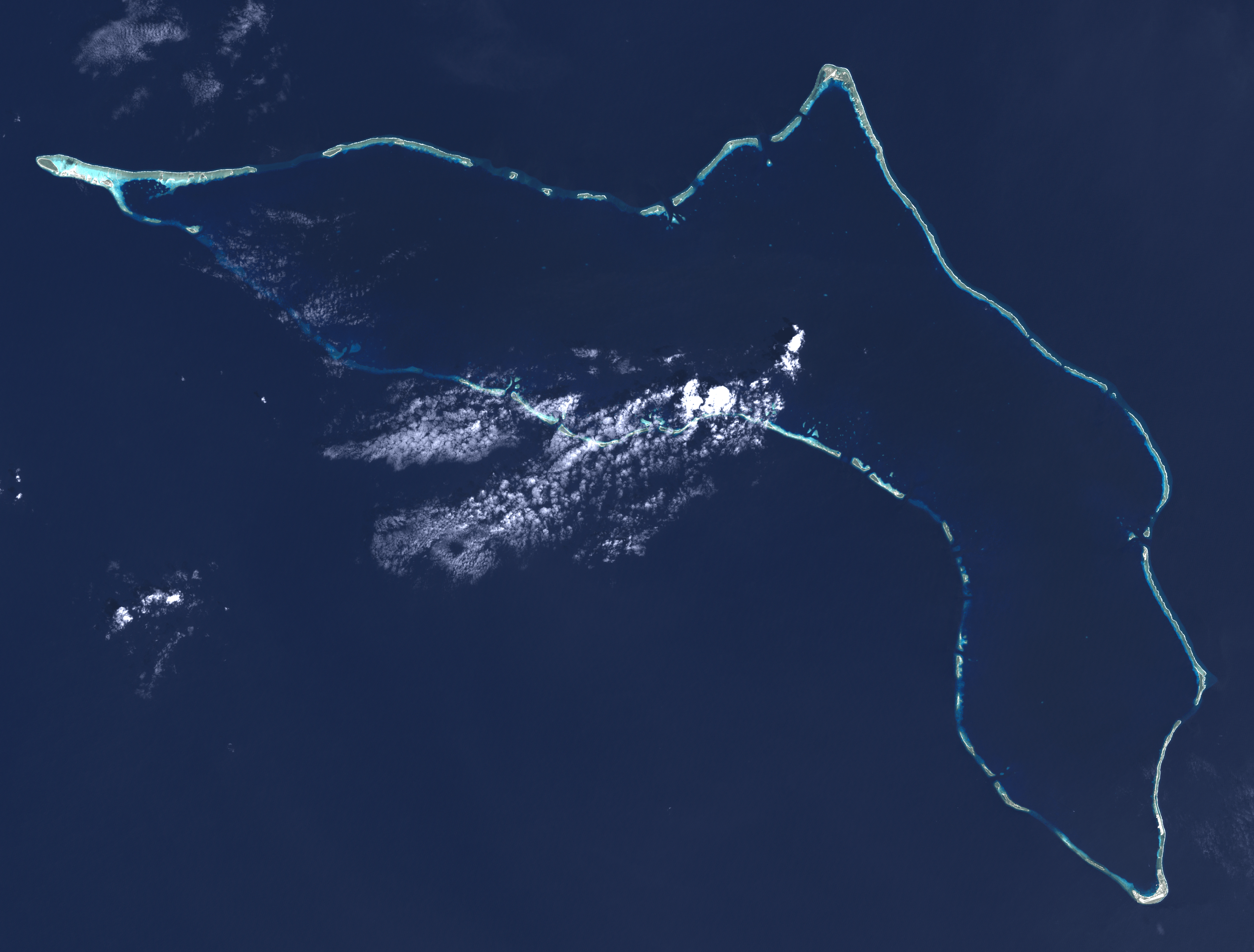
Description: Composite "true color" multispectral satellite image of Kwajalein Atoll, Republic of Marshall Islands. NASA Landsat 7 ETM+ bands used were 3 (red), 2 (green) and 1 (blue), and the image was pan-sharpened to 15m resolution, manually color balanced, and resampled to 30m output resolution. Projection: UTM (zone 58), WGS84. Imagery courtesy NASA/USGS. Much of what appears to be land in this image is actually underwater, you can see the blue tint to those areas. Kwajalein Island is the southernmost island, at the bottom right of the image. This is the center of US operations in the atoll, and the most heavily settled. Directly above it is Ebeye, the main Marshallese settlement in the atoll. A causeway runs north from Ebeye to create a string of connected islands. Some distance to the north of Ebeye, just below the middle of the right side of the image, are three small islands roughly in a triangle. The southeastern one is Meck Island, which holds a major US Army rocket testing facility. Launches are sometimes carried out from Omelek, the next island north of the cluster of three. Roi-Namur island, the second largest in the atoll, forms the northernmost location in the atoll, roughly top-center in the image. It hosts a number of large radars originally set up by ARPA and Lincoln Laboratories, but later turned over to the Army. On the extreme left is Ebadon, formerly the second largest island in the atoll before Roe and Namur were backfilled to turn them into one larger island. This island, along with a few islands to its east, were formerly a major Marshallese settlement, but many of the people moved to be closer to the US installations. The long string of islands between Ebadon and Kwajalein are relatively scarcely settled. Illegini, just east of due south of Roi-Namur, roughly the mid-point of the chain, used to be used for missile testing in conjunction with Meck, but now is used only for remote radar and camera systems.
Title: Kwajalein Atoll 2003-02-07 - Landsat 7 - 30m
Credit: NASA/USGS Landsat satellite image GeoTIFF archive, http://glovis.usgs.gov
Author: NASA
Usage Terms: Public domain
License: Public domain
Attribution Required?: No
Image usage
The following page links to this image:
