
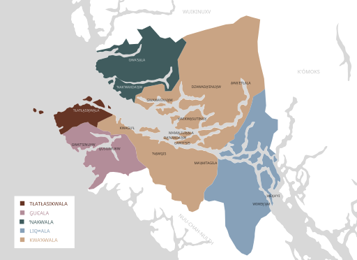
Image: Kwakʼwala map

Size of this PNG preview of this SVG file: 512 × 372 pixels. Other resolution: 320 × 233 pixels.
Original image (SVG file, nominally 512 × 372 pixels, file size: 105 KB)
Description: Map of dialects of Kwakʼwala with communities labeled. Dialect sources: http://firstnations.eu/img/04-2-0-villages-b.jpg http://www.sd85.bc.ca/wp-content/uploads/2018/06/EA2-FINAL-REPORT-June-2016-2017-Reduced.pdf Kwakʼwala communities from: http://www.languagegeek.com/wakashan/kwakwakawakw_communities.html https://www.umista.ca/pages/kwakwakawakw-tribes This file was derived from: Canada British Columbia location map.svg
Title: Kwakʼwala map
Credit: Own work
Author: Noahedits
Usage Terms: Creative Commons Attribution-Share Alike 4.0
License: CC BY-SA 4.0
License Link: https://creativecommons.org/licenses/by-sa/4.0
Attribution Required?: Yes
Image usage
The following page links to this image:

All content from Kiddle encyclopedia articles (including the article images and facts) can be freely used under Attribution-ShareAlike license, unless stated otherwise.