
Image: LaMia Airlines Flight 2933 flight path 15 minutes

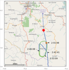
Description: LaMia Airlines Flight 2933 flight path in circular holding during the last 15 minutes (2:41:01-2:55:48 UTC). Green line indicates the plane was keeping the altitude 21,000 feet (2:46:08–2:53:09 UTC). Orange star indicates the location where ADS-B signals were lost (2:55:48). Red explosion indicates the crash site.
Title: LaMia Airlines Flight 2933 flight path 15 minutes
Credit: Own work Data source: CSV file at FlightRadar24 Location of the crash site: (N5.9805 W75.4183) Hradecky, Simon. Crash: LAMIA Bolivia RJ85 near Medellin on Nov 28th 2016, electrical problems, impact with terrain. Aviation Herald. Retrieved on 29 November 2016.
Author: Phoenix7777
Usage Terms: Creative Commons Attribution-Share Alike 4.0
License: CC BY-SA 4.0
License Link: https://creativecommons.org/licenses/by-sa/4.0
Attribution Required?: Yes
Image usage
The following page links to this image:
