
Image: LaMia Flight 2933 route map

Size of this PNG preview of this SVG file: 746 × 600 pixels. Other resolution: 299 × 240 pixels.
Original image (SVG file, nominally 1,167 × 938 pixels, file size: 683 KB)
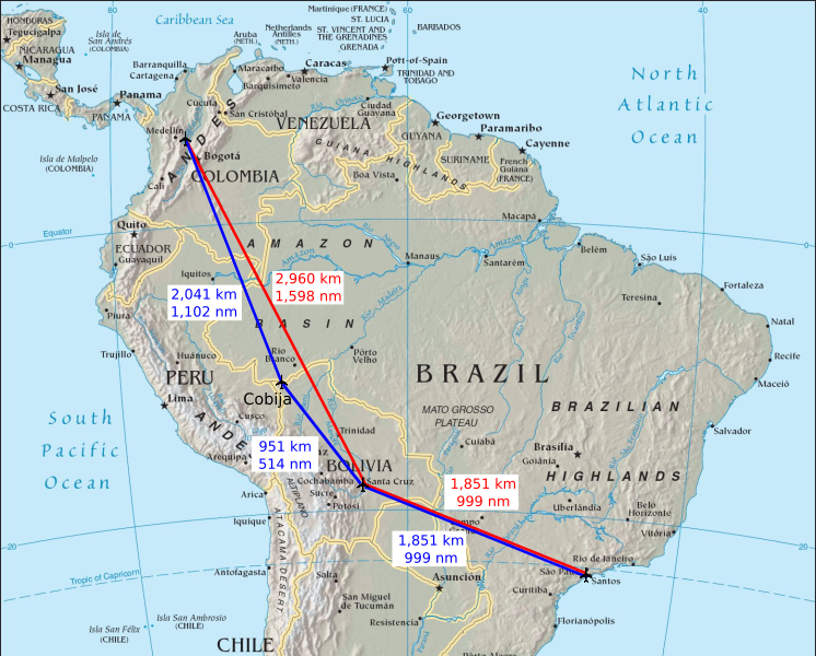
Description: LaMia Flight 2933 route map. Blue route indicates the originally planned route. Red route indicates the actual route.
Title: LaMia Flight 2933 route map
Credit: Own work Data sources: Map: File:South america.jpg GRU-VVI: 1150 mi. 1851 km 999 nm VVI-CIJ 591 mi. 951 km 514 nm CIJ-MDE: 1268 mi. 2041 km 1102 nm VVI-MDE: 1839 mi. 2960 km 1598 nm
Author: Phoenix7777
Usage Terms: Creative Commons Attribution-Share Alike 4.0
License: CC BY-SA 4.0
License Link: https://creativecommons.org/licenses/by-sa/4.0
Attribution Required?: Yes
Image usage
The following page links to this image:

All content from Kiddle encyclopedia articles (including the article images and facts) can be freely used under Attribution-ShareAlike license, unless stated otherwise.