
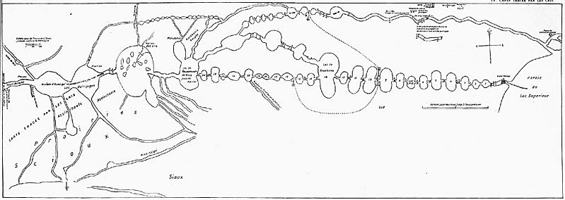
Image: La Vérendrye Map

Size of this preview: 799 × 284 pixels. Other resolutions: 320 × 114 pixels | 1,024 × 364 pixels.
Original image (1,024 × 364 pixels, file size: 70 KB, MIME type: image/jpeg)
Description: Map of Boundary Waters region, including Lake Superior, Kaministiquia River, Rainy Lake, Lake of the Woods, and Lake Winnipeg, drawn by Native guide Auchagah for La Vérendrye sometime around 1730.
Title: La Vérendrye Map
Credit: France National Archives http://epe.lac-bac.gc.ca/100/206/301/lac-bac/explorers/data2.collectionscanada.gc.ca/ap/c/c016133.jpg
Author: Auchagah
Permission: © Public Domain Credit: National Archives of Canada/C-016133
Usage Terms: Public domain
License: Public domain
Attribution Required?: No
Image usage
The following page links to this image:

All content from Kiddle encyclopedia articles (including the article images and facts) can be freely used under Attribution-ShareAlike license, unless stated otherwise.