
Image: Labrador boundary dispute

Size of this preview: 486 × 599 pixels. Other resolutions: 195 × 240 pixels | 577 × 711 pixels.
Original image (577 × 711 pixels, file size: 40 KB, MIME type: image/png)
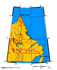
Description: Line A: the boundary decided by the Privy Council; the current legal boundary. Line B: the boundary as it is sometimes portrayed by Quebec today. Place names and lines involved in the Labrador boundary dispute. © 2004 Indefatigable. Licensed under the GFDL. Created in the GIMP using a public-domain map generated by Online Map Creation.
Title: Labrador boundary dispute
Credit: Transferred from en.wikipedia to Commons by Grillo using CommonsHelper.
Author: Indefatigable at English Wikipedia
Usage Terms: Creative Commons Attribution-Share Alike 3.0
License: CC-BY-SA-3.0
License Link: http://creativecommons.org/licenses/by-sa/3.0/
Attribution Required?: Yes
Image usage
There are no pages that link to this image.

All content from Kiddle encyclopedia articles (including the article images and facts) can be freely used under Attribution-ShareAlike license, unless stated otherwise.