
Image: Lake Piru geographic map

Size of this preview: 291 × 599 pixels. Other resolutions: 116 × 240 pixels | 955 × 1,966 pixels.
Original image (955 × 1,966 pixels, file size: 2.97 MB, MIME type: image/png)
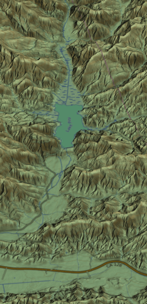
Description: Computer generated 3D view of Santa Clarita, CA (center) and vicinity. Viewing direction is North, oblique view. Also visible: Lake Piru (West/left), Bouquet Reservoir (Northeast/top right), Castaic Lake (North/top center). Elevation data: National Elevation Dataset; map (texture) data: © OpenStreetMap; 2D rendering (map layout) © OpenTopoMap. 3D Rendering software: TruFlite
Title: Lake Piru geographic map
Credit: Own work
Author: Martin D. Adamiker
Usage Terms: Creative Commons Attribution-Share Alike 4.0
License: CC BY-SA 4.0
License Link: https://creativecommons.org/licenses/by-sa/4.0
Attribution Required?: Yes
Image usage
The following page links to this image:

All content from Kiddle encyclopedia articles (including the article images and facts) can be freely used under Attribution-ShareAlike license, unless stated otherwise.