
Image: Leeuwin current 2
No higher resolution available.
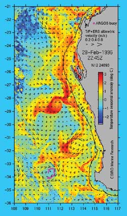
Leeuwin_current_2.jpg (250 × 425 pixels, file size: 30 KB, MIME type: image/jpeg)
Description: Satellite imagery from US NOAA 14 satellite while the surface current velocity is derived from sea level measurements made by the satellite-borne altimeter. Sea level data from the US/French Topex/Poseidon and European ERS altimeters are combined with coastal tide gauge data to make this velocity map.
Title: Leeuwin current 2
Credit: NOAA
Author: National Oceanic and Atmospheric Administration
Usage Terms: Public domain
License: Public domain
Attribution Required?: No
Image usage
The following page links to this image:

All content from Kiddle encyclopedia articles (including the article images and facts) can be freely used under Attribution-ShareAlike license, unless stated otherwise.