
Image: Lower Egypt-en

Size of this preview: 600 × 600 pixels. Other resolutions: 240 × 240 pixels | 994 × 994 pixels.
Original image (994 × 994 pixels, file size: 188 KB, MIME type: image/png)
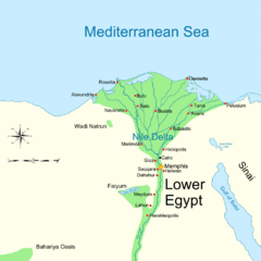
Description: Map of Lower Ancient Egypt, showing the Nile and major cities and sites of the Dynastic period (c. 3150 BC to 30 BC).
Title: Lower Egypt-en
Credit: Ancient_Egypt_map-en.svg
Author: Ancient_Egypt_map-en.svg: Jeff Dahl derivative work: MinisterForBadTimes (talk)
Usage Terms: Creative Commons Attribution-Share Alike 3.0
License: CC BY-SA 3.0
License Link: https://creativecommons.org/licenses/by-sa/3.0
Attribution Required?: Yes
Image usage

All content from Kiddle encyclopedia articles (including the article images and facts) can be freely used under Attribution-ShareAlike license, unless stated otherwise.