
Image: MODIS Aqua SoCal (Bands 7, 4, and 3) 2025-01-08T21 40Z (cropped2)
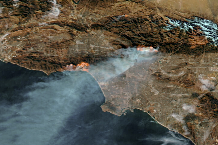
Description: An image from the MODIS instrument on the Aqua satellite taken over Greater Los Angeles on 8 January 2025 at 21:40GMT, showing the in the north. To the south, dust being blown offshore by the en:Santa Ana winds can be seen. This is a "false color" image assembled from Band 7 (2130nm) for red, Band 4 (555nm) for green, and Band 3 (469nm) for blue, with the overall color being adjusted to match that of the "true color" image. The infrared band used for the red channel allows the fires themselves to be more clearly seen, and makes the smoke (but not clouds or dust) appear more transparent.
Title: MODIS Aqua SoCal (Bands 7, 4, and 3) 2025-01-08T21 40Z (cropped2)
Credit: Assembled from https://wvs.earthdata.nasa.gov/api/v1/snapshot?REQUEST=GetSnapshot&TIME=2025-01-08T00:00:00Z&BBOX=27.4117,-123.8865,35.324,-115.9742&CRS=EPSG:4326&LAYERS=MODIS_Aqua_CorrectedReflectance_Bands721&WRAP=day&FORMAT=image/tiff&WIDTH=3601&HEIGHT=3601&colormaps=&ts=1736460404660 and https://wvs.earthdata.nasa.gov/api/v1/snapshot?REQUEST=GetSnapshot&TIME=2025-01-08T00:00:00Z&BBOX=27.4117,-123.8865,35.324,-115.9742&CRS=EPSG:4326&LAYERS=MODIS_Aqua_CorrectedReflectance_TrueColor&WRAP=day&FORMAT=image/tiff&WIDTH=3601&HEIGHT=3601&colormaps=&ts=1736460328460 (via https://worldview.earthdata.nasa.gov/)
Author: MODIS Land Rapid Response Team, NASA GSFC
Usage Terms: Public domain
License: Public domain
Attribution Required?: No
Image usage
The following page links to this image:

_2025-01-08T21_40Z_(cropped2).jpg)