
Image: MOD map, Iranian arrest of Royal Navy personnel
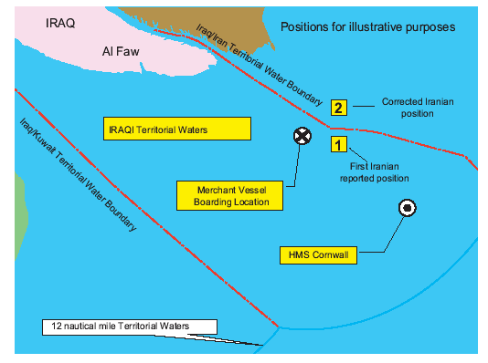
Description: Map issued by the Ministry of Defence at a media briefing (28 March 2007) on the position of Royal Navy personnel when arrested by Iran. The Foreign Affairs Select Committee inquiry later found that this map was "less clear than it ought to have been" after hearing evidence that the water boundary shown had merged the land boundary that follows the Shatt al-Arab waterway and about 8 nautical miles (15 km) of land exposed at low tide with the median line between the two unshown low water lines, and that the 1975 Algiers Agreement "southern terminal point ... lies just under 1.7 nautical miles northeast of the position" shown on this map.
Title: MOD map, Iranian arrest of Royal Navy personnel
Credit: https://publications.parliament.uk/pa/cm200607/cmselect/cmfaff/880/88001.gif Context: https://publications.parliament.uk/pa/cm200607/cmselect/cmfaff/880/88006.htm
Author: Ministry of Defence
Permission: This file is licensed under the United Kingdom Open Government Licence v3.0. You are free to: copy, publish, distribute and transmit the Information; adapt the Information; exploit the Information commercially and non-commercially for example, by combining it with other Information, or by including it in your own product or application. You must, where you do any of the above: acknowledge the source of the Information in your product or application by including or linking to any attribution statement specified by the Information Provider(s) and, where possible, provide a link to this licence; If the Information Provider does not provide a specific attribution statement, you must use the following:Contains public sector information licensed under the Open Government Licence v3.0. This licence does NOT cover: personal data in the Information; Information that has not been accessed by way of publication or disclosure under information access legislation (including the Freedom of Information Acts for the UK and Scotland) by or with the consent of the Information Provider; departmental or public sector organisation logos, crests and the Royal Arms except where they form an integral part of a document or dataset; military insignia; third party rights the Information Provider is not authorised to license; other intellectual property rights, including patents, trade marks, and design rights; and identity documents such as the British Passport.Consult this guide for full details.Note: Since 2010, almost all information owned by the UK Crown is offered for use and re-use under the Open Government Licence by authority of The Controller of His Majesty's Stationery Office.info See also: Meta for information on usage on Wikimedia wikis.Open Government License 3OGL 3http://www.nationalarchives.gov.uk/doc/open-government-licence/version/3true
Usage Terms: Open Government License 3
License: OGL 3
License Link: http://www.nationalarchives.gov.uk/doc/open-government-licence/version/3
Attribution Required?: Yes
Image usage
The following page links to this image:
