
Image: Manchester Metrolink Second City Crossing map

Size of this preview: 754 × 599 pixels. Other resolutions: 302 × 240 pixels | 1,259 × 1,001 pixels.
Original image (1,259 × 1,001 pixels, file size: 868 KB, MIME type: image/png)
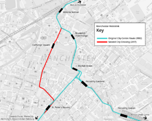
Description: Map of Manchester City Centre showing the routes of the original Metrolink tram line (1992) and the Second City Crossing (2018)
Title: Manchester Metrolink Second City Crossing map
Credit: Own work
Author: Cnbrb
Usage Terms: Creative Commons Zero, Public Domain Dedication
License: CC0
License Link: http://creativecommons.org/publicdomain/zero/1.0/deed.en
Attribution Required?: No
Image usage
There are no pages that link to this image.

All content from Kiddle encyclopedia articles (including the article images and facts) can be freely used under Attribution-ShareAlike license, unless stated otherwise.